- Home
- World
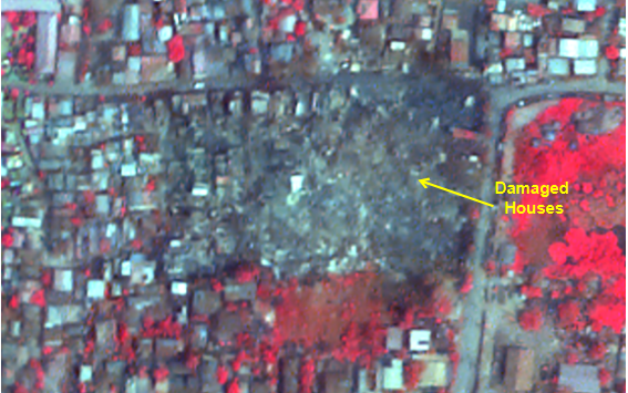
- Myanmar earthquake aftermath: ISRO's satellite images reveal massive destruction; see photos
Myanmar earthquake aftermath: ISRO's satellite images reveal massive destruction; see photos
A powerful 7.7 magnitude earthquake struck Myanmar, causing massive destruction, killing thousands, and prompting international rescue efforts, with ISRO’s satellite images revealing the full extent of the devastation.
- FB
- TW
- Linkdin
 "ISRO’s Satellite Images Reveal Widespread Destruction")
ISRO’s Satellite Images Reveal Widespread Destruction
In the wake of the devastating 7.7 magnitude earthquake that struck Myanmar on March 28, 2025, satellite images released by India's Space Research Organization (ISRO) have provided a chilling look at the extent of the destruction. Captured by ISRO's Cartosat-3 satellite from 500 kilometers above Earth, the high-resolution photographs show significant damage across the affected areas, underscoring the severity of the disaster.

Mandalay and Surrounding Regions Suffer Heavy Damage
The earthquake, which was centered near Myanmar’s second-largest city, Mandalay, has caused widespread devastation. Mandalay, located near the epicenter, has seen some of the most significant destruction. Key infrastructure, including a major bridge over the Irrawaddy River, has collapsed, crippling transportation and communication. Additionally, Mandalay University has suffered extensive damage, with many of its buildings reduced to rubble. Numerous highways and roads have also been destroyed, making access to the hardest-hit areas difficult.
Rising Death Toll and Ongoing Rescue Operations
The official death toll has surpassed 1,700, with thousands more injured. As emergency teams continue to search for survivors, the number of casualties is expected to rise. Neighboring regions, particularly Sagaing, have also experienced heavy damage, including the collapse of iconic landmarks such as the Ava Bridge and the Mahamuni Pagoda.
Global Support and Myanmar’s Road to Recovery
The disaster has not been confined to Myanmar alone. The earthquake's tremors were felt across the border, affecting parts of Thailand. The Thai government quickly mobilized emergency response teams to provide assistance, joining the international effort to aid Myanmar in its recovery.
Myanmar's military government has declared a state of emergency as rescue operations intensify. Emergency responders are combing through the rubble to locate survivors, while relief efforts are being coordinated on the ground. Aid has poured in from various countries, with India among the first to deploy rescue teams. India's rapid response has been pivotal in assisting Myanmar during this critical period.
Satellite Data Assisting in Damage Assessment
In addition to emergency rescue efforts, satellite images provided by ISRO are being used to assess the full extent of the damage and plan the next steps for reconstruction. The data is proving invaluable for relief teams as they navigate the challenging terrain and coordinate their operations.
As Myanmar grapples with the aftermath of the earthquake, the international community remains committed to providing support as the country begins its long road to recovery. The damage is severe, but the resilience of the people and the continued flow of aid provide hope amid the overwhelming devastation.
